
Using gravity to predict floods is a weighty topic. So when satellites that measure gravity have something to say, we listen:
By the GRACE of satellites, scientists can now predict flooding! (via NASA)
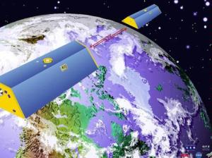
NASA satellites monitor changes in the earth’s gravity field. Yes—gravity changes! So what does that have to do with flooding? JT Reager of the NASA Jet Propulsion Laboratory says shifting water masses play a role in gravity change.
“If you have more water in a region, you have more mass there,” he explains. “And more mass is associated with more gravity. And therefore changes in water can cause changes in gravity.”
So think of river basins as buckets. When they’re almost full of snow, soil moisture, and groundwater, the NASA satellites will measure a small increase in gravity – alerting us that the system is saturated and more likely to flood with added precipitation.
Reager says that by combining gravity measurements with weather forecasts, we could see floods coming about five months in advance. That lead time could be huge for farmers and public safety planners working to defend against extreme weather.
Get Schooled:
-
Floored by the news? Learn more in this article from Science
- GRACE your brain by reading about NASA’s Grace Mission (Gravity Recovery and Climate Experiment)
- Check out this GRACE article by JT Reager and colleagues from Nature Geosciences
- Flood your understanding of satellites and floods with this article from NASA
The fine print:
- This segment was produced in partnership with Cornell’s Atkinson Center for a Sustainable Future