
GPS stations can detect drought
by measuring when the earth’s crust lifts or depresses.
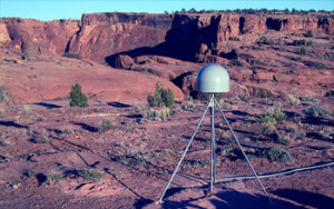
Image credit: NSF.gov
Transcript of the Audio Podcast:
A surprising discovery from GPS technology…on this CurrentCast.
In the western United States, a network of highly precise GPS stations measure the movement of tectonic plates – collecting data about possible earthquakes. Scientists have discovered, quite by accident, they can also track the region’s water loss.
Borsa: “No one knew that you could actually see a drought signal on a GPS…”
That’s Adrian Borsa, a researcher at Scripps Institution of Oceanography. He says at the end of 2012, GPS data showed a rapid uplift in the earth’s crust. The surface rose because, due to drought, it was no longer weighted down by water.
Borsa says this GPS technology may help scientists track and monitor water resources.
Support for CurrentCast comes from the Mitsubishi Corporation Foundation for the Americas. Learn more online at http://www.current-cast.org.
Learn More:

Adrian Borsa, Scripps Institution of Oceanography
- Conservation Fisheries Inc. “GPS is Tracking West’s Vanishing Water, Scientists Surprised to Learn” from National Geographic
- “Severe Drought is Causing the Western U.S. to Rise” from Scripps Institution of Oceanography
- “US drought has literally raised the ground, say scientists”from Christian Science Monitor
- Adrian Borsa’s web site